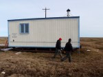
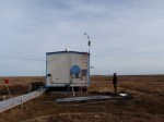
Our goal for the day was to mount a weather station and multiple cameras on a hut. In addition, we wanted all of these devices to collect data and feed it real-time back to the servers we installed earlier in the week at the BARC. I will provide a more detailed explanation of the data communication systems that are in use in a later post. The hut we went to was located in the Barrow Environmental Observatory (BEO), a 7,466 acre research area just outside of Barrow. The land was set aside in 1992 by the Ukpeaġvik Iñupiat Corporation (UIC) for research. In 2003 the North Slope Borough (NSB) rezoned the land to become the Scientific Research District (SRD). Due to the BEO, Barrow has become the principal arctic location in the United States for the study of the ocean, land and atmosphere.
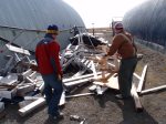
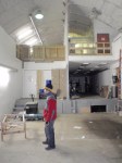
Before going to the hut, we scavenged through some wood and metal pipe so we would have material to build mounts. We also picked up some tools in one of the storage buildings which look like mini airplane hangars around the NARL. Once out at the hut, we set to work in mounting the cameras and weather station, running the wires, and confirming that the data was flowing properly back to the BARC. We were successful in getting everything working. In fact, I went out on the Tundra in front of one of the cameras and called my wife in Ohio and she was able to confirm that she could see me dancing around on the tundra.
We called it a day about 8PM with only one remaining issue we could not resolve. The mount for the weather station did not allow us to level it properly. The mount assumes that the wall it is mounted on is straight, and the hut is not level. So we will need to come back tomorrow with some additional metal pipe, wood and tools to mount it properly. However, the quality of the weather data is secondary to the fact that we are able to reliably collect that data in near real-time from the field. So even if we don’t get the station leveled tomorrow, we still accomplished our main goal.